Persistence Pays Off: Wightman Surveyor Traces the Evidence to Write the Next Chapter in a 170-year Land Survey Story
Article | 07.06.2020By Gary Hahn, PS, Regional Manager, Survey, Kalamazoo, Wightman
As many good mysteries do, this story begins several years ago.
In 1996 a young surveyor, Gary Hahn, and his wife, Julie, were antiquing in Two Rivers, Wisconsin. They came across a curious piece in the basement of a shop—a section of tree with scarred bark that had been preserved as a display piece.
But this wasn’t just any display piece. It represented a small piece in a much larger system under which all land ownership in Michigan is based. The discovery of this artifact would be the first step of a 23-year investigative journey to trace its origins and visit the land on which the tree once stood.
To understand what the Hahns had found, you need to go back to the 1800s to when the United States government set out to survey and map the land now known as Michigan so parcels could be sold for logging, mining, farming, and settlement.
At that time, Michigan was a vast network of dense forests, rivers and streams, marshes, and ravines. Government survey teams were dispatched into the wilderness to measure, mark, and divide the land into one-square-mile sections. The lines of the sections were marked at 1/2-mile intervals by wooden posts called “section corners.” This created a grid that overlays the upper and lower peninsulas upon which all land parcels were, and continue to be, referenced. In an effort to inventory the land and so that others would know where to look for the section corners, survey teams wrote detailed narratives about soil, timber, bodies of water, unique land characteristics, and bearing trees.
Bearing trees serve as a reference points from which section corners can be located. It was the duty of the axe man who traveled with each survey team to blaze, or strip bark from, nearby trees and etch “BT” into the exposed trunk.
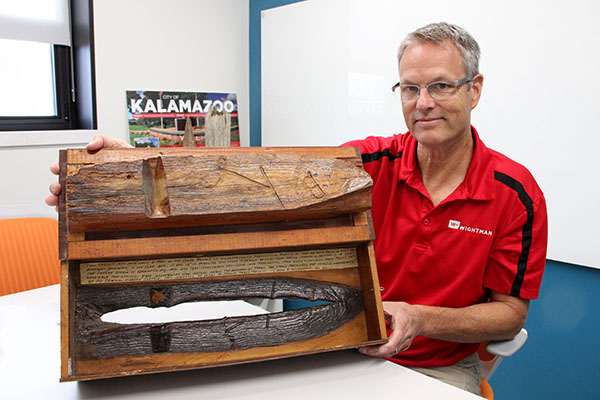
What Hahn found in the basement of the antique shop was a remnant of one of these bearing trees. The creator of the exhibit, land surveyor Harold C. Lawrence, visited the section corner marked by this tree in 1940 only to find that the bearing tree had fallen. He built a hinged display case from salvaged pieces of the tree on which he inscribed the following:
This exhibit was originally a part of the cedar marked on U.S. government subdivisional survey of Town 48 North Range 16 West of Michigan meridian, in the year 1850. It was 12” in diameter and stood N 53 degrees West 22 links from corner common to sections 17 – 18 – 19 & 20. The severe storm of Armistice Day – Nov. 11th 1940 shattered this cedar into fragments, from which I salvaged the pieces to assemble this exhibit. This illustrates how nature heals the wounds on trees. The storm prevented the complete crossing over of the original marked surface. This indicates 90 years of growth never the less.
(Memo by H. C. Lawrence – Nov 1940)
Hahn, who is Regional Survey Manger in Wightman’s Kalamazoo office and serves as Kalamazoo County Surveyor, began his career in the early 1980s. Given his background, he knew he was looking at a piece of Michigan survey history and purchased the artifact.
“I’ve spent my career as a Professional Surveyor in Michigan’s lower peninsula where evidence from the original government surveys has been obliterated, for the most part, by farming and development. When I saw the bearing tree display, I knew I had found something unique,” stated Hahn. “I felt compelled to purchase it and discover more about its maker and the section corner associated with it.”
Upon returning home, Hahn researched maps of the original government surveys and learned that the origins of the piece were based in Michigan’s upper peninsula, near the Lake Superior shoreline in Alger County. At the time, the internet was in its infancy, so further access to detailed information about the corner position was difficult to come by. The bearing tree display stayed safely in his office.
Fast forward two decades. Hahn remained intrigued by the unanswered questions posed by his antique store find. He resumed research with the aid of Google Earth and its capacity to show survey section lines superimposed over maps. From Google Earth, Hahn determine the approximate latitude and longitude of the section corner position, which lay within Pictured Rocks National Lakeshore. Astoundingly, while 420 miles from his home, it was only 20 miles from his wife’s hometown.
In July 2015, Hahn and his family traveled to Munising, the county seat of Alger County, to visit family. He used the opportunity to attempt to locate the section corner. Based on mapping information, the corner position was remote and would only be accessible by hiking in on foot. Equipped with a compass, hand-held GPS, machete, shovel, and a few other items, Hahn set out along the North Country Trail until his GPS showed he was due north of the corner position.
From there, he had to leave the trail and head south over rugged terrain of sand dunes and thick vegetation. The off-trail hike, covering just half of a mile, took more than two hours. With GPS keeping him on course, Hahn crossed a stream—likely the one referenced by the 1850 survey team. Walking parallel to the stream while using a metal detector, he located and excavated a piece of heavy gauge wire that looked like it may have been wrapped around a square post. Wondering if this could this be evidence of the corner he was looking for, he dug deeper in search of remnants of the wood stake set in 1850 by the original government survey team but quickly hit water. Because no other corner evidence was observed, and knowing he had a difficult return hike ahead of him, he left a three-foot long metal rebar over the hole he dug, packed his gear, and hiked out of the forest.
A year later, in 2016, Hahn and his family returned to Munising. With a new plan in mind, he decided to make a second attempt to determine the original position of the section corner. Accompanied by his nephew Anthony Mattson, Hahn journeyed to a point one-half mile west of the suspected section corner location.
He based the new plan on survey notes from 1950 documented by surveyor Ray J. Brotherton, who completed a Land Corner Record for The Cleveland-Cliffs Iron Company Forest Products division. In it, Brotherton referenced finding a “scribed 4” post…set by H.C. Lawrence” at the corner Hahn was looking for and measuring west 2,657 feet to “a similar H.C. Lawrence post.” It was this second post Hahn hoped to find. He theorized that if he could find the second post and measure between it and the wire remnant he had found in 2015 that he could compare this measurement to Brotherton’s 1950 measurement to confirm the corner position.
After hiking to the wire remnant location, Hahn and his nephew used a compass and a 100' tape to measure west 2,657 feet to search for the second H.C. Lawrence post referenced by Brotherton. They found no evidence of the post, but did discover an iron rod with a Northern Michigan University study cap buried in the ground. They also found metal washers nailed to nearby trees likely used to mark, or witness, the iron rod’s location.
Following this trip, research revealed that Northern Michigan University had performed a study in the Pictured Rock National Forest to map the likely location of prehistoric Native American camp sites, based on the prehistoric location of the Lake Superior shoreline. This explained the iron rod they found. However, the research did not reveal whether or not it represented the position of a section corner. As a result, it did not help to determine whether or not the wire remnant was marking the position of the section corner being sought by Hahn.
From what Hahn was able to observe during his two exploratory hikes, he concluded he needed to plan his next trip for the spring or fall, when vegetation and leaves aren’t so thick, and use survey-quality GPS equipment to make more accurate measurements.
In 2019, Hahn got his chance.
Once again, the Hahn family traveled to Munising, this time over Memorial Day. Hahn was able to bring along GPS equipment from work, and the trees did not yet have their full foliage. He intended to continue the search for remnants of H.C. Lawrence’s cedar posts using GPS to measure between evidence previously found. It was still his hope to relate a current measurement to the 1950 Brotherton measurement to either prove the corner location or point him toward additional evidence.
Hahn began his work at the capped iron rod used in the Northern Michigan University study by attempting to obtain its accurate GPS coordinates. Unfortunately, foliage in this area was too thick to lock onto GPS satellites. Hahn moved a half mile east to see if he would have better luck at the wire remnant location. GPS readings told him he was due north of the corner. He headed south until he arrived at the stream referenced in the 1850 survey notes.
Looking across the stream, he spotted florescent survey ribbon he had left hanging from a tree in the vicinity of the wire remnant. As Hahn stood looking for a safe landing spot for a leap across the stream, he glanced to his left and there, not more than four feet away, was a 4" x 4", eight-foot tall cedar post standing straight and just below the north bank of the stream. It was the cedar post H.C. Lawrence had set 79 years earlier to mark the section corner common to sections 17, 18, 19, and 20 on the day in 1940 when he found the corner’s bearing tree laying nearby.
“I truly could not believe my eyes,” Hahn stated. “Having been so close to it on previous searches and then glancing up to see it just four feet away as I was about to jump across the stream, I was astonished. The post must have been well hidden by foliage for it to have remained unseen on my two previous visits.”
Hahn set about obtaining GPS coordinates of the corner position. Upon inspecting the sun-bleached post, Hahn noticed extensive decay at its base. He photographed the post, cut the top off, and set the 3' rebar at the base—the very rebar he left in the woods four years earlier. He then set nails in nearby trees as witness ties and began his return hike.
He had been so close in 2015. Basing his search on the original 1850 site description, he had looked for the section corner post on the south side of the stream. What he did not realize was that over 170 years, the stream had meandered northward so that the post was now in the stream.
As a County Surveyor, one of Hahn’s roles is to participate in a statewide project to perpetuate and remonument section corners. Knowing how difficult finding and verifying remote and long unattended section corners can be, Hahn contacted Dustin Taylor, P.S. and Alger’s County’s representative to the State Survey and Remonumentation Program to see if he could run this corner through Alger County’s Remonumentation Program.
Hahn asked if he could obtain and set a standard Alger County Remonumentation Monument at the corner during a return visit he and his family planned for the 4th of July. Taylor agreed and made arrangements for Hahn to pick up the monument.
With monument in hand, Hahn, his 13-year-old daughter Isabelle, and family friend Doug Miron of Munising, hiked back to remove the decaying remnant of the cedar post, set the monument, and officially perpetuate the section corner. His daughter blazed four new bearing trees, just as the axe man of the 1850 survey team had done, to establish new witness ties.
On November 4, 2019, the Alger County Peer Review Group approved the Land Corner Recordation Certificate Hahn had submitted. It was recorded with the Alger County Register of Deeds to officially document the findings for future surveyors, closing this chapter on the section corner H.C. Lawrence documented in 1940 with a display piece purchased 56 years later by a professional surveyor from Michigan.
Hahn’s journey from the basement of the Wisconsin antique shop in 1996 to officially documenting the section corner in 2019 is a story of persistence. When asked why he continued to pursue his search over 23 years, Hahn commented that through the display H. C. Lawrence made from the bearing tree remnants, he felt a direct link to the Government Land Office axe man Josiah Woodworth who blazed the bearing tree in 1850.
“I just felt a desire to learn as much as I could about Josiah Woodworth, H.C. Lawrence, and the section corner,” Hahn stated. “Many aspects of this adventure have been rewarding—from walking in the footsteps of the original government surveyors through Pictured Rock National Forest, to finding H.C. Lawrence’s cedar post monument, to watching my daughter blaze a new bearing tree with an axe.”
As for the display piece and the top of the cedar post from the section corner, Hahn plans to display both at Wightman’s office in Kalamazoo.
Services